Two Hardyston properties qualify as ‘in need of redevelopment’
Hardyston. The properties headed for this special designation under the New Jersey Local Redevelopment and Housing Law were found to present challenges to development, including soft soils, steep slopes, massive boulders, and marshland.

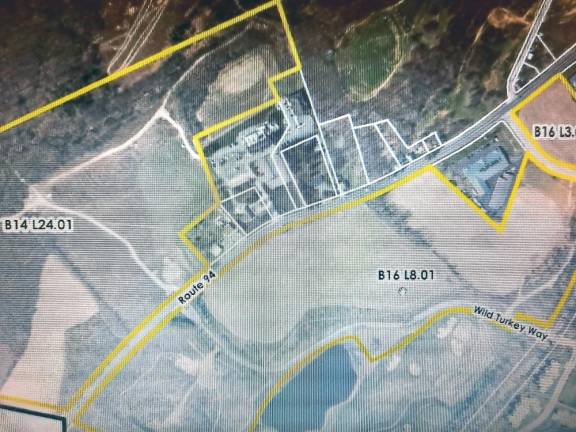
The Hardyston Planning Board held a special meeting on Dec. 10 to determine whether three undeveloped lots off Route 94 qualify for redevelopment in accordance with the New Jersey Local Redevelopment and Housing Law.
The law provides municipalities with economic development tools in areas designated as being “in need of redevelopment,” also known as “blighted.”
Carrine Piccolo-Kaufer, the Hardyston township manager, said land qualifies if it is owned by a municipality, has been unimproved and vacant for ten years, and is not likely to be developed by private developers because of its location, remoteness, lack of access to developed sections of the municipality, topography, or nature of the soil. Two of the three lots were found to qualify as “in need of redevelopment.”
Leigh Fleming, who works for the community planning firm of Heyer, Gruel, and Associates in Red Bank, N.J., presented the board with the findings of her investigation into the three properties, Block 16 Lots 8.01 and 3.03, and Block 14 Lot 24.01. The Block 16 lots are aligned along the southern side of Route 94, and the Block 14 lot fronts the northern side. All three are located in the Highlands Planning Area and are zoned Commercial Recreation-Village Center, which permits a range of residential and commercial uses.
For her investigation, Fleming reviewed geospatial mapping data, tax maps, ownership records, aerial photos, historic aerial images, environmental data, and township records. She said she conducted a field investigation on Jan. 9, 2020. Here are the highlights of her report:
Block 14, Lot 24.01
The investigation found that Block 14, Lot 24.01 meets the criteria for an area in need of redevelopment.
The property almost 50 acres, including 8.5 acres of marshland. The property includes a perennial stream that flows into the Wallkill River. It has 1,044 feet of frontage along Route 94 and is irregularly shaped.
The property includes gravel trails that divide the property both north and south, and east and west. The only development is a concrete pad and partial wall on the far west side. Metal containers sit in fenced-in area on the east side. These elements may be seen in the aerial imagery.
The southern site of the property contains crop lines. The northern and western portions of this property contain wetlands, steep slopes, wooded areas, and streams.
Some parts have steep slopes considered severe. A soil study of the north and south sides in the area of Wild Turkey Way was done in 2005.
The natural soils are expected to be exposed following the removal of topsoil and fill, and to contain silty sands and sandy silts — a mix of fine and coarse grains. This type of soil tends to be soft and difficult to build on.
No permits have been issued for the property, which means conditions haven’t changed since the 2005 report. Subsurface boulders will make excavation challenging. Remedies include moving the topsoil and fill, and compacting the silty sands and sandy silts.
Block 16, Lot 8.01
Block 16, Lot 8.01, also meets the criteria as an area in need of redevelopment. It is 43.5 acres of undeveloped land on the south side of Route 94. It fronts two roads: the primary lot is along Route 94 and then loops around another parcel, Lot. 3.04, and fronts Van Decker Road. This property is part of the Crystal Springs development and contains Wild Turkey Way. It is an entryway to the rest of Crystal Springs.
Fleming said soil conditions, as they are now, would hinder redevelopment. This property also contains steep slopes.
Block 16, Lot 3.03
Block 16, Lot 3.03 does not meet the criteria for a need for redevelopment because it does not have any soil contamination or environmental restraints.
This property is a corner Lot with 330 feet of road frontage.
Piccolo-Kaufer said that based on Fleming’s presentation, the planning board agreed to designate two of the three properties in need of redevelopment. The next step is review and action by the Hardyston Township Council.